Availability of Urban Functions by rail and by road, 2011
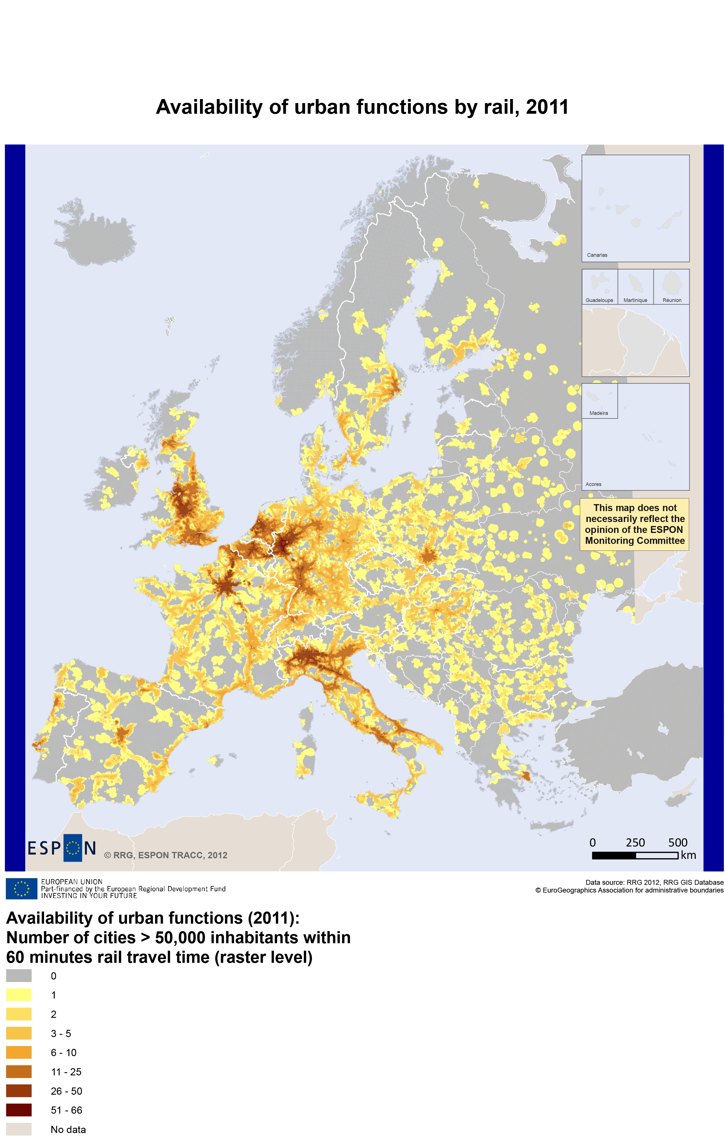

Urban Functions by rail (left image); Urban Functions by road (right image)
Policy context
The European transport system serves a key role in the transportation of people and goods in a local, regional, national, European and international context. At the same time, the European transport system is essential to Europe’s prosperity and closely linked to economic growth and quality of life.
Accessibility is the main 'product' of a transport system. It determines the locational advantage of a region relative to all regions. Indicators of accessibility measure the benefits households and firms enjoy from the existence and use of the transport infrastructure relevant for their area. The important role of transport infrastructure (i.e. networks and transport services) for regional development in its most simplified form implies that regions with better access to the locations of materials for production and services and to markets will be more productive, more competitive and hence more successful than regions that are more remote and isolated regions.
Access to and availability of public and private services and functions provided in urban areas is crucial for daily life of citizens. Such services and functions are often not all offered in small towns and villages or in the countryside, and in those cases people require easy access to them in nearby cities. The higher the number of cities that can be reached from a given location in reasonable time, the more opportunities to benefit from public and private services and functions are provided as well as for economic and social activities and for general interactions.
The indicator “availability of urban functions” measures the number of cities that can be reached from any location within 60 minutes travel time. The higher the number of cities is, the higher the accessibility and thus the higher the attractiveness of a location is. Cities with at least 50,000 inhabitants are selected as destinations, assuming that only cities of that minimum size provide a full basket of public and private services and functions.
Observations
The indicator highlights the most agglomerated areas in Europe. Availability of urban functions is the highest in the Ruhr area, England, the region around Paris, in the Benelux countries and in Northern Italy. Some capital city regions in other countries (for instance, Stockholm, Madrid, Budapest or Athens) also stand out, as well as other selected regions such as Oslo-Gothenburg-Malmö-Copenhagen, Barcelona-Valencia-Murcia, Lyon, Saxony, Naples and Upper Silesia with its city systems.
From most locations in Western and Central Europe, at least one city can be reached by road within 60 minutes, from many places even more than ten. In Eastern Europe, mostly only one or two cities are within reach. Locations from where only one city can be reached have normally only access to basic urban services. Usually, people from there do not have the possibility to go to another city to make use of certain facilities, but they are bound to just one closest city. Locations from where more than one city can be reached, have options to visit different cities offering a wider range of services, i.e. these locations provide more freedom of choice and thus more opportunities.
The map also clearly highlights that many regions in Europe do not have access to urban functions within reasonable time. Such areas are not only located in the far North (Northern peripheral sparsely populated areas) or in the Alpine space, as maybe expected, but they also cover so-called ‘inner peripheries’ which for road can be found basically in all European countries. Prominent examples of these are Mecklenburg-Vorpommern (Germany), many parts in France or Spain, or areas in Poland or Czech Republic. For rail the extent of these areas is even bigger in almost all countries. Consequently, while the road indicator tends to form seamless coverage at raster level, for rail the major railway axes become clearly visible.
Points for Policy consideration
The main findings concerning access to urban services and functions for businesses and for citizens can be summarized as follows:
- From most locations in Europe at least one city can be reached in less than 60 minutes travel time.
- People in Western Europe have often the option to visit more than five different cities in one hour (i.e. they enjoy greater freedom of choice and thus more opportunities).
- However, the results also show that within the large majority of European countries, citizens and businesses in many regions have limited access to urban services and functions.
- Regions in the far North, but also ‘inner peripheries’ of a number of countries, even within Central Europe, are lacking access to cities within one hour.
- Disparities between regions are greater for rail than for road. In addition, the inner peripheries for rail are much larger than for road. This means that people bound to public transport (pupils, young, elderly, retired etc.) have less access to a large variety of urban services and functions compared to car users.
Concept/method/measurement
For this indicator trans-European road and rail networks, a population at the grid level (EEA, 2012) as well as the location of 1,760 cities with more than 50,000 inhabitants in Europe (destinations) are used. The RRG GIS database used includes in addition to the trans-European road and rail networks also relevant road and rail ferries.
For each raster cell of the 2.5x2.5 km grid system the travel time by road and rail to all cities of more than 50,000 inhabitants has been calculated. If the travel time is less than 60 minutes, the destination is within reach and is added to the number of destinations for that raster cell.
More information
- This Map of the Month is a result of the ESPON Applied Research “TRACC - TRansport ACCessibility at regional/local scale and patterns in Europe’’
- Contact at the ESPON Coordination Unit: Marjan van Herwijnen ([email protected])
Documents

|
Map of the Month "Availability of Urban Functions by rail and by road, 2011"
|
|

|
Map "Availability of Urban Functions by rail, 2011"
|
|

|
Map "Availability of Urban Functions by road, 2011"
|

